Rammert Run

The Season this year is coming to an end and we took the opportunity to do an orienteering competition that’s a little bit different than we’re used to. At the Rammert Run you have to run as a pair together and do a score-o in 3 hours. You have to run the entire race together an cannot split up the controls. The controls aren’t the white orange ones you know from orienteering, there are just small white papers sticked to trees with codes on them. The map was just a topographical map with a scale of 1:21500. Our start time was around 10:30 and the fog was still there. We decided quickly for a direction we wanted to go and see then how many controls we could get in time. At the beginning it was a lot of road and path running so we made up a rough plan that we wanted to check after around half the time. After the first control wer decided to go more directly and cut the long distances of the paths and trails. The first half of our race was much up and down so we had to climb a lot and we did it cross-country. After the fog started to clear up we had some nice views with still some fog over the trees. Just a little after an hour in the race we checked out timing and decided how the race would continue for us. Later we decided to risk something and try to get an extra control with the option to let one go in the end. But in the end we had some time left so it were quite enjoyable last meters to the finish. After mir than 21k and 750m climb we finished in first place with just one control more than the second team. We had a lot of fun and a good long training.

The last climb today
One of the controls
The map

Go long or go home – ultralong sprint training

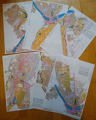
One of my clubmates made a quite big sprint map covering downtown Stuttgart, downtown Bad Cannstatt, the surrounding parks a some more. Earlier this I was a little bored a designed a course that covers the whole map. I ended with a 26.7 k straight line, 62 controls ultralong sprint course. It can be printed on six A3 or 11 A4 sheets. On rainy Sunday in August we made to run the course. We needed 3 h 38 min and run 32.6 k but made to use the whole map and visit some new parts of the city. You can see the map with the course here. Contact us for the map if you came to Stuttgart and like to run the course too.

six A3 sheets of one orienteering map

Battelfield Bühlertann or playing in the mud

After one year break the Rats Runners obstacle races are back. In 2019 I run two races (Bühlertann and Kupferzell) of the series. This year only Bühlertann will take place. The race in Bühlertann is hosted by the local motocross club that has a lot of experience with mud. Originally we planed to run with a team and challenge for the victory in the team category as we did in Kupferzell 2019. Unfortunately several date changes made me a solo starter. The running course is 10.5 k mainly trail/cross with several river crossings an steep and slippery parts. Hard people can go for two rounds. Perfect running terrain for orienteers. Highlight is the motocross track in the end of the course. Design of all obstacles made it possible to get other it alone. Obstacles are mainly place on two parts of the course. After one third around the BMX course (muddy challenge) and at the very end of the course (field of tears, 10 obstacles on the last 600 m). If anybody asks why to do this the slogan of the series “Stronger people are harder to kill” is a good answer. I not completely satisfied with my run as had some problems with strength (gym was closed too long) and running speed (too less orienteering competitions). I managed to run 3 mins faster than 2019 and finished 4th in the Silver Boys (M40+) class 2 min behind 3rd place. For next year I´ll try to manage the podium and hopefully we will have a team again.
My GPS track: https://www.attackpoint.org/sessiondata.jsp?sessionid=7563731
Pictures: https://www.rats-runners.de/buehlertann-2021.html
Results: https://www.rats-runners.de/ergebnisse.html?eventCode=RR-2021-03&classCode=RP

Retro map training

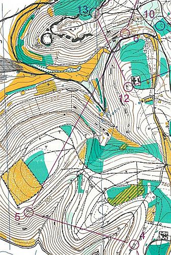
Did you ever had the chance to train on a nearly 40 years old map? It’s something that could be really fun. My club organized a training on a map from 1984. The area between Heubach and Bartholomä is great for orienteering and was features in the series “Germanies best orienteering areas”. The map is still great and on many parts you even can recognize the vegetation. We run the superlong course that has 13.4 k straight line and some nice route choices. We end up 18.1 k running and 640 m climb. As usual you can find the map in our map archive. Note that the contour interval is 10 m.

part of the course

Regional Championships middle Baden-Württemberg

The first regional event this year was the regional championships organized by the SV Wannweil. Even though I wasn’t a big part of the organization this year I had to set and pick controls, so there was no chance for me to run in the championships. The map in Ohnastetten on the Schwäbische Alb is in some parts really stony and especially these parts were used in the course setting. Most Competitors were grateful we held the competition, as all the other competitions in the region were canceled so far. The difficult courses and small fields of competitors had the effect of longer victory times.

Steffen was one of the competitors in the H19 class and ended up in second place.

  1. Per Dammeier 1:17:41
  2.  Steffen Hartmann  1:20:26
  3. Manuel Werner 1:56:03

Results can be found here and for the maps check out our map archive.

Essinger Panoramalauf

Saturday we had the first competition this year. We started at the 3 hill run of the Essinger Panoramalauf (Essinger landscape run). A 23 k race with ~500 m climb. The event was resheduled from June last year to November last year and finally to June this year. There were some restrictions like no drinks on course but otherise it was a good competion feeling. We run the 23 K course first time so it wasn´t easy to find the right speed. Worked quite fine for Jakob and OK for me.
Jakob: 1:43:23 (12th total, 3rd M30)
Steffen: 2:09:34 (71st total, 13th M40)
Results:
https://lac-essingen.de/panoramalauf/#0_0D6FAD

After race drink.